Robots at the Edge of the Map: Safer Field Science in Water, Farms, and Beyond
From flooded caves to fragile coral reefs and densely planted crop rows, many important research sites are difficult or unsafe for people to visit often. Small, sensor‑rich machines are starting to go instead, mapping, sampling, and watching as natural systems shift over hours, seasons, and long stretches of time. Human experts stay farther from harm while still gaining a detailed view.
This story is part of DailySeekers's practical reading library across everyday topics.
Why Small Machines Go Where People Shouldn’t
When a place can crush, freeze, burn, or poison a person in minutes, sending a compact machine instead of a human is a practical choice. Deep water, unstable ice, and active volcanic zones can be beyond what the human body can safely tolerate.
Robotic platforms slip through narrow rock cracks, glide under ice shelves, or sit for months on a seabed ridge while sensors log temperature, pressure, or chemical changes. No one has to camp on unstable ground or dive in strong currents just to check a reading.
Because these systems operate without a person beside them, they can stay in place for long periods, making slow trends in climate, biodiversity, or geology easier to see. Instead of a few snapshots from short expeditions, researchers can build continuous records with less personal risk.
Fieldwork that relies heavily on people is not only risky; it is also complicated and expensive. Travel, permits, safety plans, training, and rescue options all add time and cost. In some locations, rules block direct human access because the hazard or biological risk is judged too high.
Machines designed for heat, pressure, or cold that would threaten a person can move through these locations with fewer restrictions. Running largely on their own, they collect measurements day and night without food, rest, or a return ticket. A single deployment can replace repeated visits by research teams, lowering both cost and exposure to harm.
| Choice point in planning | When people on site make sense | When small machines are a better fit |
|---|---|---|
| Access and safety | Conditions manageable with standard protective gear | Conditions that quickly exceed safe limits for trained staff |
| Time scale of interest | Short studies where a few visits are enough | Slow shifts that require long, uninterrupted observation |
| Terrain and reach | Open, stable ground or shallow water | Tight spaces, deep water, or unstable surfaces |
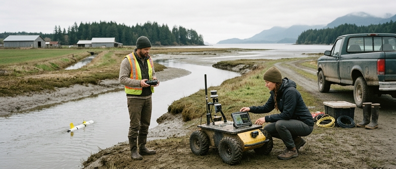
How Trips Become Data: Cameras, Sensors, and Samplers
Seeing and describing the scene
A journey into the field only becomes scientifically useful when it produces structured information. Cameras and sensors are the main tools for turning what a platform “experiences” into shareable records.
Mobile units can carry RGB cameras, depth cameras, and laser scanners to map crops, soil, rocks, or water. In plant research, video or image streams are fused with position data so every frame links to a specific location and time. That makes it possible to track growth, color change, or disease patterns.
Perception is also about invisible features. Temperature, humidity, gas, and chemical sensors add context that the eye alone cannot provide. A patch of stressed plants that looks normal in regular images may stand out in thermal or multispectral data. When all inputs are time‑stamped and geo‑referenced, a single day outside becomes a structured dataset that can be compared across weeks, months, or years.
Touch, grip, and turning samples into numbers
Once a system can see, it still needs to interact with the environment. Robotic arms with joint sensors, tactile pads, and wrist‑mounted cameras help pick fruit, collect soil cores, or grab bottles without crushing or dropping them.
Sampling tools close the gap between “holding an object” and “having a useful measurement.” In environmental work, water intakes can pump through filters that capture genetic traces for later analysis. In geology, automated drillers cut cores, seal them, and record depth and position. Each sample receives an identifier tied to sensor logs and images taken at the moment of collection.
Back in the lab, measurements such as nutrient levels, particle content, or genetic markers can be linked to those identifiers. Researchers build structured tables that connect physical samples to the exact conditions under which they were taken.
| Sampling task | Example robotic action | How it helps later analysis |
|---|---|---|
| Water quality survey | Pumping water through onboard filters | Creates labeled filter sets ready for lab tests |
| Soil structure study | Drilling shallow cores and sealing tubes | Preserves layering and moisture for later inspection |
| Plant health check | Snipping leaf discs into numbered vials | Links lab readings to precise plants and time points |
Oceans, Forests, and Farms With Machines on the Job
Night shifts in fields and orchards
In many row crops, routine fieldwork is changing as autonomous units take the “night shift,” moving between plants while people rest.
Guided by satellite navigation and onboard cameras, these platforms follow precise paths through dense vegetation. Instead of spraying entire areas uniformly, they inspect each row to locate weeds, stressed leaves, or gaps where seedlings never emerged. Some units remove weeds, others record where problems appear so decisions can focus on the most affected patches.
Overhead, small flying systems or rail‑mounted cameras travel along the same rows, zooming in on seedlings and mature plants. By tracking size, color, and shape over time, they help estimate growth rates and likely harvest windows. This shift replaces occasional spot checks with frequent, repeatable measurements across whole plots.
Linking reefs, forests, and farms
In shallow seas, compact machines shaped like fish or small submersibles weave through coral heads, measuring water conditions and filming reef surfaces. In forests, insect‑like devices and four‑legged platforms move under canopies, across burned slopes, and over loose ground, mapping vegetation recovery or helping to plant seedlings.
The common thread with farm work is the style of activity: small, regular, data‑focused visits instead of rare, all‑day campaigns. Whether the task is checking coral bleaching, counting forest insects, or spotting weeds between lettuce plants, machines can follow the same route repeatedly under similar conditions.
For people involved in field studies, roles adjust. Less time goes into driving, diving, or hiking the same transects, and more time goes into deciding where to send the machines, how to configure their sensors and tools, and how to interpret the streams of information they bring back.
What Can Go Wrong and How Reliability Is Protected
Common ways things fail outdoors
Moving complex systems from clean labs into fields, disaster zones, or clinics exposes them to new ways of failing. Hardware can overheat, jam with dust or sand, leak, or run out of power far from help. A stuck arm in a lab is inconvenient; a stuck arm holding a sample in a contaminated zone can create safety concerns and destroy weeks of planning.
There are also limits in basic physical skills. Many platforms that can plan paths or label images accurately still struggle with tools like pipettes, caps, or switches. A machine may “understand” an experimental protocol but fail to twist a lid tight enough or press a button with the right force. In field science, these small errors can spoil samples, introduce contamination, or distort data.
Workplace disruption is another risk. If organizations rush to replace experienced technicians with automated systems before those systems are stable, problems can hide behind a polished image. When a single person on site is responsible for several fragile units, one fault can quickly cascade into a larger failure if it goes unnoticed.
Keeping systems trustworthy
To maintain trust, teams build in safeguards at several levels. On the hardware side, machines are tested against dexterity and safety benchmarks using familiar tools and tasks. If a platform cannot reliably handle everyday instruments, it is not moved into critical outdoor roles where mistakes are hard to correct.
Before deployment in health, environmental, or emergency settings, oversight groups review designs and test results, checking that devices align with approved safety expectations. Newer review frameworks look at whole systems: backup power, communication links, emergency stop procedures, physical barriers, and data logging all matter.
Human‑in‑the‑loop checks remain central even when tasks are largely automated. People review key decisions, watch for unusual behavior, and can pause or shut down a system when needed. Teams are encouraged to share failure reports and near‑miss accounts so one group’s hard‑earned lessons can prevent repeated mistakes elsewhere.
As more fieldwork relies on these tools, the goal is not blind trust in machines but a careful partnership. By combining human judgment with persistent, precise sensing and sampling, researchers can explore more of the planet while keeping both people and fragile environments safer.
Q&A
-
How is robotics in field science changing the way researchers design studies in harsh environments?
Robotics in field science lets researchers plan questions around continuous, fine‑scale measurements rather than brief human visits. In harsh environments, robots can follow dense sampling grids, repeat transects precisely, and maintain standardized protocols, enabling stronger statistics, better model validation, and more ambitious experimental manipulations with lower logistical overhead. -
What are the main technical benefits of remote data collection compared with manual fieldwork?
Remote data collection provides higher temporal resolution, consistent measurement procedures, and integrated metadata such as position and calibration histories. Automated logging reduces transcription errors and missing values, while networked systems allow near real‑time monitoring and adaptive sampling strategies, for example changing survey frequency when thresholds are crossed or anomalies appear. -
In what ways do underwater robot surveys advance ocean and freshwater ecosystem research?
Underwater robot surveys extend observation into deeper, darker, and more dynamic zones where divers cannot reliably work. They carry acoustic, optical, and chemical payloads, mapping gradients in temperature, nutrients, and biodiversity. Long‑endurance missions reveal episodic events like algal blooms or hypoxic pulses that short human dives almost always miss. -
How do automated sampling tools improve data quality and sample integrity in field projects?
Automated sampling tools standardize timing, volume, and handling steps, reducing variability introduced by different people or fatigue. They can pre‑label, seal, and track samples with embedded identifiers and logs, preserving chains of custody. This improves comparability across campaigns, simplifies audits, and strengthens confidence in downstream statistical and molecular analyses. -
How does technology assisted observation contribute to safety in research access without weakening scientific insight?
Technology assisted observation shifts people away from direct exposure while preserving rich situational awareness through multimodal data streams. High‑resolution imagery, environmental sensors, and remote control interfaces let experts interpret subtle patterns from safe locations. Coupled with redundant systems and alerts, this approach reduces accident risk without sacrificing analytical depth or responsiveness.